
Creation year
2022
10 record(s)
Type of resources
Available actions
Topics
Keywords
Contact for the resource
Provided by
Years
Formats
Representation types
Update frequencies
Status
Scale
panaceaKeywords
GEMET keywords
-
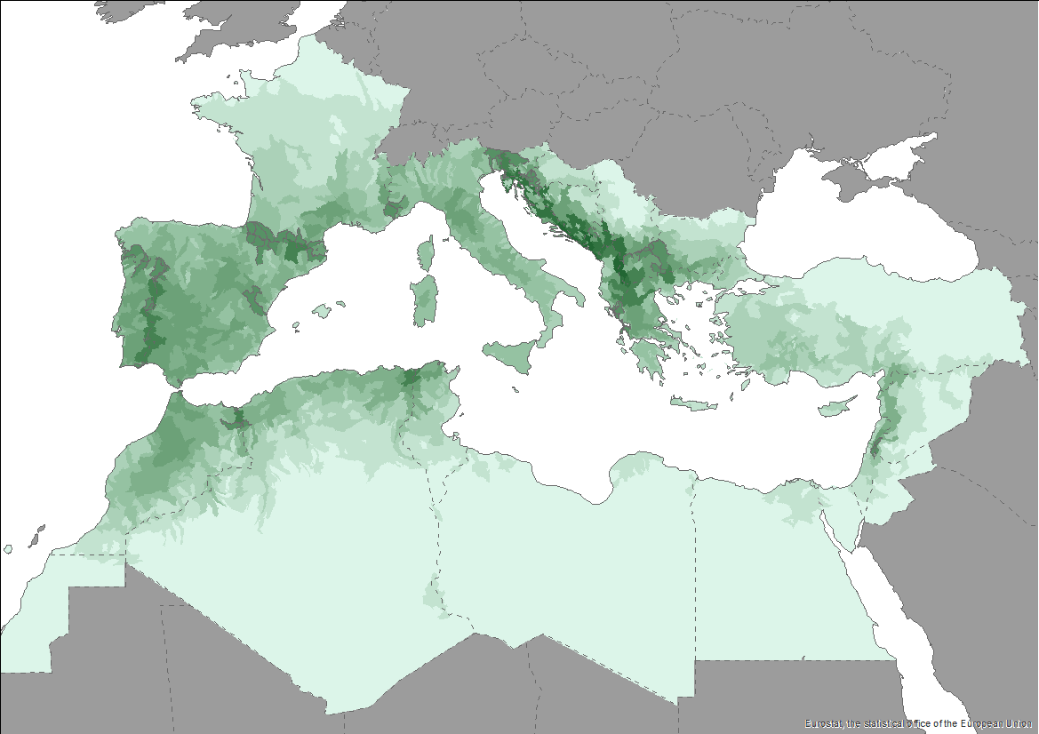
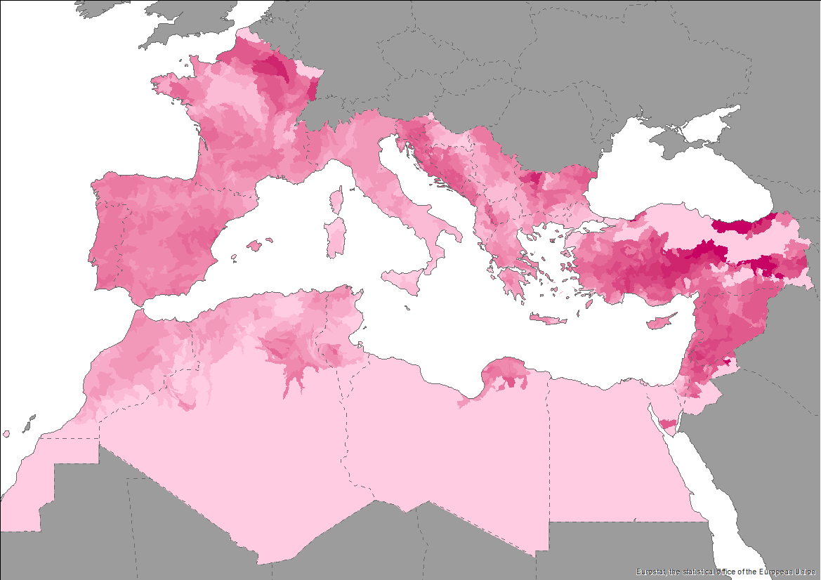
The Pan-Mediterranean wetland knowledge base builds on methods and approaches developed in the framework of on-going efforts at the Mediterranean scale to map wetland ecosystems and assess their condition. It is relevant for several on-going initiatives at a regional, European and global level (e.g. UN Decade on Ecosystem restoration, EU Biodiversity Strategy for 2030, the Barcelona Convention and its protocols on Integrated Coastal Zone Management and Specially Protected Areas). As part of these efforts, ETC-UMA produced an assessment that targets the distribution, state and trends of pressures and impacts on key animal and plant biodiversity hosted by wetland habitats in the Mediterranean region. The assessment of wetland biodiversity conditions aims to complement existing knowledge and address the lack of readily available spatially-explicit information on the areas where biodiversity unique to the Mediterranean occurs, and where endemic biodiversity is most threatened, using data from The Red List of Threatened Species™ of the International Union for Conservation of Nature (IUCN). For the threatened species analysis, only species categorised in the IUCN Red List as Critically Endangered (CR), Endangered (EN) and Vulnerable (VU) were considered. The goal is to highlight priority areas for potential conservation actions in the region, and to support the regional efforts in advocating for effective wetland management and nature-based solutions in the Mediterranean region.
-
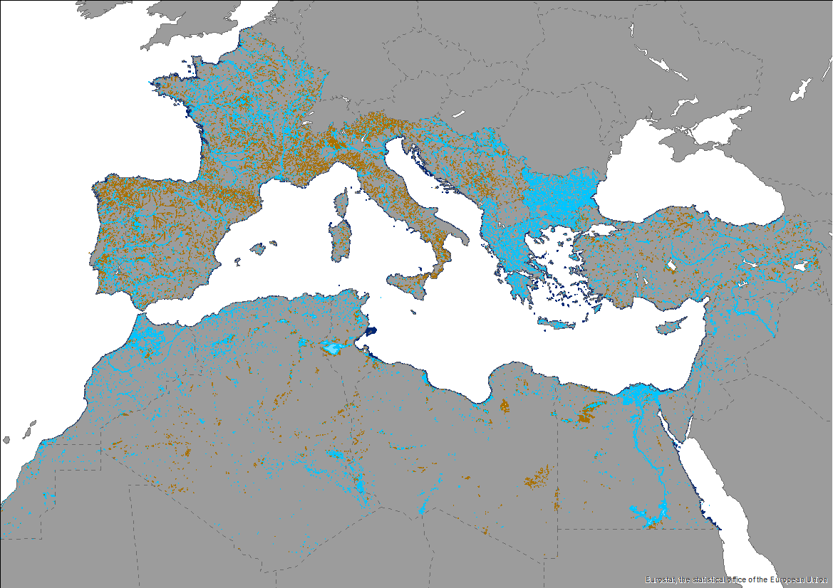
This knowledge base builds on methods and approaches developed in the framework of on-going efforts at the Mediterranean scale to map wetland ecosystems and assess their condition. It is relevant for several on-going initiatives at a regional, European and global level (e.g. UN Decade on Ecosystem restoration, EU Biodiversity Strategy for 2030, the Barcelona Convention and its protocols on Integrated Coastal Zone Management and Specially Protected Areas). The development of the products presented in this report was carried out through a collaborative process that aimed to engage key players and stakeholders working on different aspects and scales of wetland mapping and habitat identification in the Mediterranean region. The Pan-Mediterranean wetland knowledge base constitutes the first step in building and making available a harmonised knowledge base across the whole region on the spatial extent, distribution and type of wetlands in the Mediterranean region. Despite the amount of data ingested and the variety of contributors, large areas of the whole basin still lack detailed and reliable regional data, which makes the final Pan-Mediterranean wetlands map worth improving as data and knowledge becomes more available and accessible over time. Further efforts are needed to identify available higher resolution data for specific areas.
-
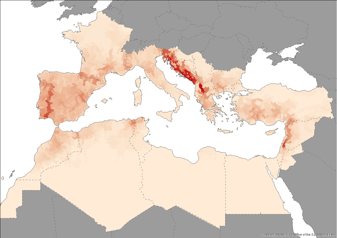
The Pan-Mediterranean wetland knowledge base builds on methods and approaches developed in the framework of on-going efforts at the Mediterranean scale to map wetland ecosystems and assess their condition. It is relevant for several on-going initiatives at a regional, European and global level (e.g. UN Decade on Ecosystem restoration, EU Biodiversity Strategy for 2030, the Barcelona Convention and its protocols on Integrated Coastal Zone Management and Specially Protected Areas). As part of these efforts, ETC-UMA produced an assessment that targets the distribution, state and trends of pressures and impacts on key animal and plant biodiversity hosted by wetland habitats in the Mediterranean region. The assessment of wetland biodiversity conditions aims to complement existing knowledge and address the lack of readily available spatially-explicit information on the areas where biodiversity unique to the Mediterranean occurs, and where endemic biodiversity is most threatened, using data from The Red List of Threatened Species™ of the International Union for Conservation of Nature (IUCN). For the threatened species analysis, only species categorised in the IUCN Red List as Critically Endangered (CR), Endangered (EN) and Vulnerable (VU) were considered. The goal is to highlight priority areas for potential conservation actions in the region, and to support the regional efforts in advocating for effective wetland management and nature-based solutions in the Mediterranean region.
-
This knowledge base builds on methods and approaches developed in the framework of on-going efforts at the Mediterranean scale to map wetland ecosystems and assess their condition. It is relevant for several on-going initiatives at a regional, European and global level (e.g. UN Decade on Ecosystem restoration, EU Biodiversity Strategy for 2030, the Barcelona Convention and its protocols on Integrated Coastal Zone Management and Specially Protected Areas). The development of the products presented in this report was carried out through a collaborative process that aimed to engage key players and stakeholders working on different aspects and scales of wetland mapping and habitat identification in the Mediterranean region. The Pan-Mediterranean wetland knowledge base constitutes the first step in building and making available a harmonised knowledge base across the whole region on the spatial extent, distribution and type of wetlands in the Mediterranean region. Despite the amount of data ingested and the variety of contributors, large areas of the whole basin still lack detailed and reliable regional data, which makes the final Pan-Mediterranean wetlands map worth improving as data and knowledge becomes more available and accessible over time. Further efforts are needed to identify available higher resolution data for specific areas.
-
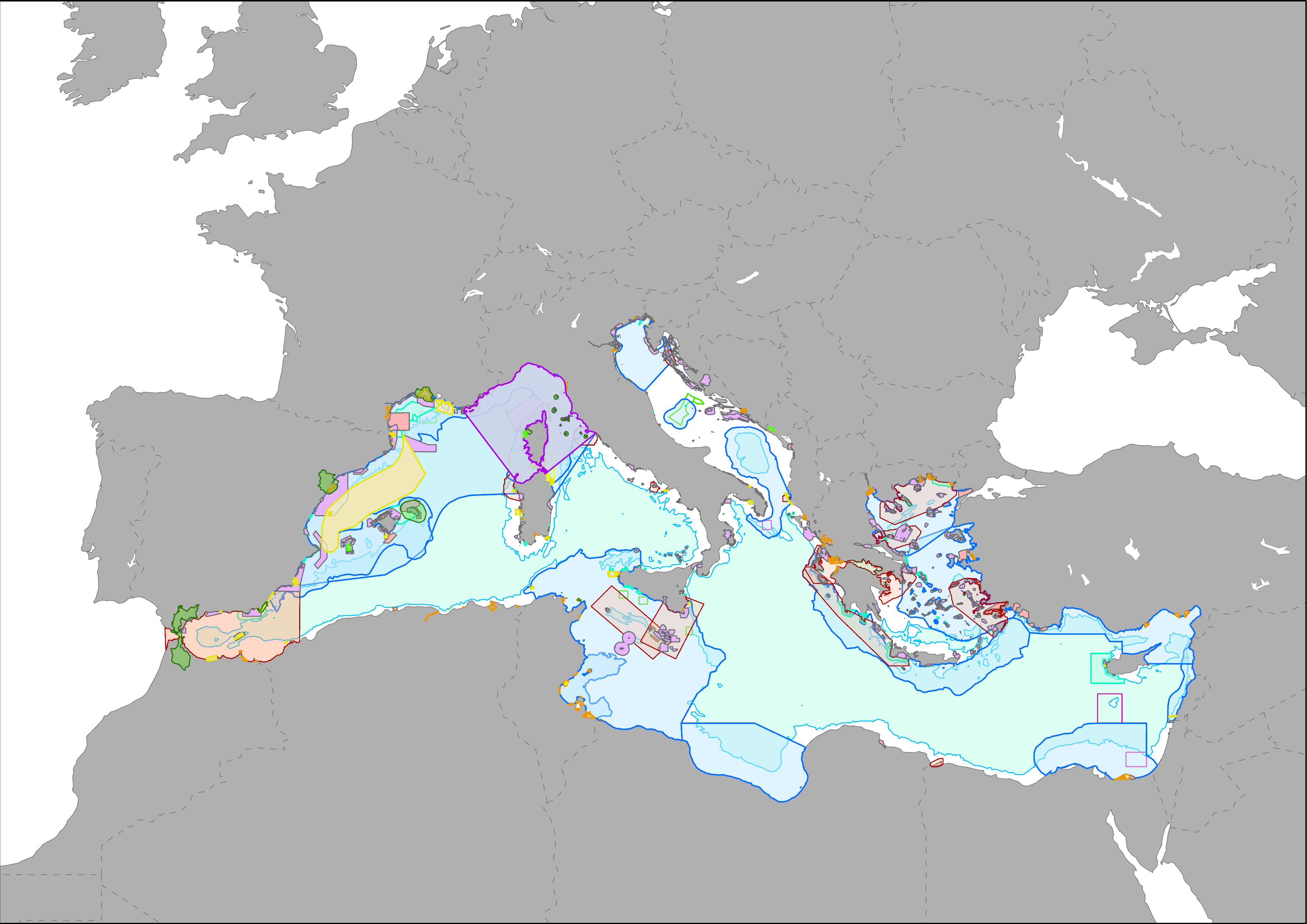
MAPAMED (MArine Protected Areas in the MEDiterranean) is a cartographic database of key information on Mediterranean Marine Protected Areas (MPAs), potential Other Effective area-based Conservation Measure (OECMs), and more broadly on sites of interest for marine conservation. It is developed and administered jointly by UNEP/MAP-SPA/RAC and the MedPAN Association. For detailed information, please consult the MAPAMED user manual (April 2021 version).
-
This knowledge base builds on methods and approaches developed in the framework of on-going efforts at the Mediterranean scale to map wetland ecosystems and assess their condition. It is relevant for several on-going initiatives at a regional, European and global level (e.g. UN Decade on Ecosystem restoration, EU Biodiversity Strategy for 2030, the Barcelona Convention and its protocols on Integrated Coastal Zone Management and Specially Protected Areas). The development of the products presented in this report was carried out through a collaborative process that aimed to engage key players and stakeholders working on different aspects and scales of wetland mapping and habitat identification in the Mediterranean region. The Pan-Mediterranean wetland knowledge base constitutes the first step in building and making available a harmonised knowledge base across the whole region on the spatial extent, distribution and type of wetlands in the Mediterranean region. Despite the amount of data ingested and the variety of contributors, large areas of the whole basin still lack detailed and reliable regional data, which makes the final Pan-Mediterranean wetlands map worth improving as data and knowledge becomes more available and accessible over time. Further efforts are needed to identify available higher resolution data for specific areas.
-
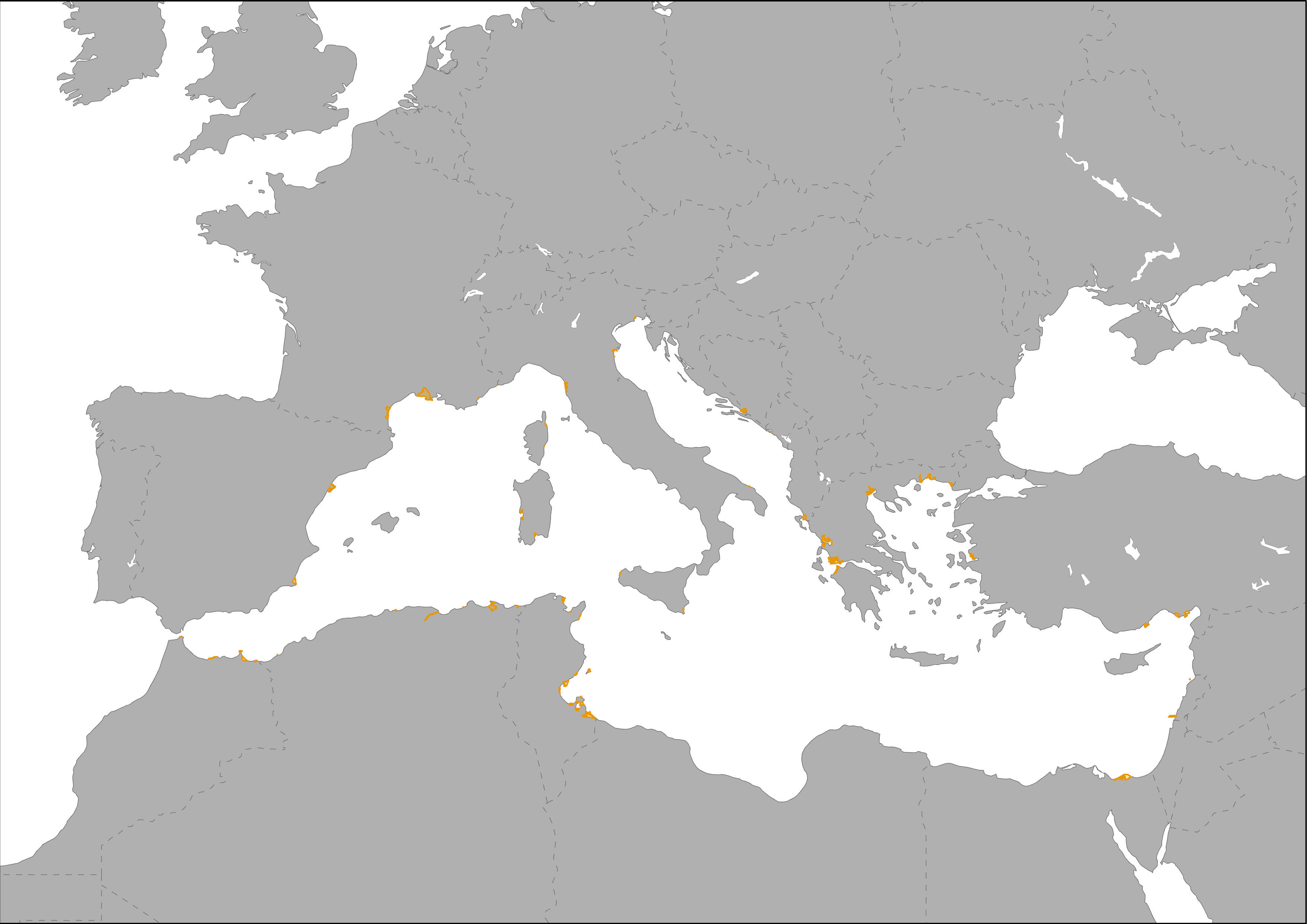
Under the Convention on Wetlands (Ramsar, 1971), each Contracting Party undertakes to designate at least one wetland site for inclusion in the List of Wetlands of International Importance. There are over 2,000 "Ramsar Sites" on the territories of over 160 Contracting Parties across the world. All Site information is provided by the Contracting Parties to the Convention. Responsibility for the accuracy and completeness of the data lies with the Administrative Authority of the Party that has added the Site to the List of Wetlands of International Importance. These areas are recollected into MAPAMED which is a cartographic database of key information on Mediterranean Marine Protected Areas (MPAs) potential Other Effective área-based Conservation Measure (OECMs), and more broadly on sites of interest for marine conservation. It is developed and administered jointly by UNEP/MAP-SPA/RAC and the MedPAN Association. For detailed information, please consult the MAPAMED user manual (April 2021 version).
-
The Pan-Mediterranean wetland knowledge base builds on methods and approaches developed in the framework of on-going efforts at the Mediterranean scale to map wetland ecosystems and assess their condition. It is relevant for several on-going initiatives at a regional, European and global level (e.g. UN Decade on Ecosystem restoration, EU Biodiversity Strategy for 2030, the Barcelona Convention and its protocols on Integrated Coastal Zone Management and Specially Protected Areas). As part of these efforts, ETC-UMA produced an assessment that targets the distribution, state and trends of pressures and impacts on key animal and plant biodiversity hosted by wetland habitats in the Mediterranean region. The assessment of wetland biodiversity conditions aims to complement existing knowledge and address the lack of readily available spatially-explicit information on the areas where biodiversity unique to the Mediterranean occurs, and where endemic biodiversity is most threatened, using data from The Red List of Threatened Species™ of the International Union for Conservation of Nature (IUCN). For the threatened species analysis, only species categorised in the IUCN Red List as Critically Endangered (CR), Endangered (EN) and Vulnerable (VU) were considered. The goal is to highlight priority areas for potential conservation actions in the region, and to support the regional efforts in advocating for effective wetland management and nature-based solutions in the Mediterranean region.
-
This knowledge base builds on methods and approaches developed in the framework of on-going efforts at the Mediterranean scale to map wetland ecosystems and assess their condition. It is relevant for several on-going initiatives at a regional, European and global level (e.g. UN Decade on Ecosystem restoration, EU Biodiversity Strategy for 2030, the Barcelona Convention and its protocols on Integrated Coastal Zone Management and Specially Protected Areas). The development of the products presented in this report was carried out through a collaborative process that aimed to engage key players and stakeholders working on different aspects and scales of wetland mapping and habitat identification in the Mediterranean region. The Pan-Mediterranean wetland knowledge base constitutes the first step in building and making available a harmonised knowledge base across the whole region on the spatial extent, distribution and type of wetlands in the Mediterranean region. Despite the amount of data ingested and the variety of contributors, large areas of the whole basin still lack detailed and reliable regional data, which makes the final Pan-Mediterranean wetlands map worth improving as data and knowledge becomes more available and accessible over time. Further efforts are needed to identify available higher resolution data for specific areas.
-
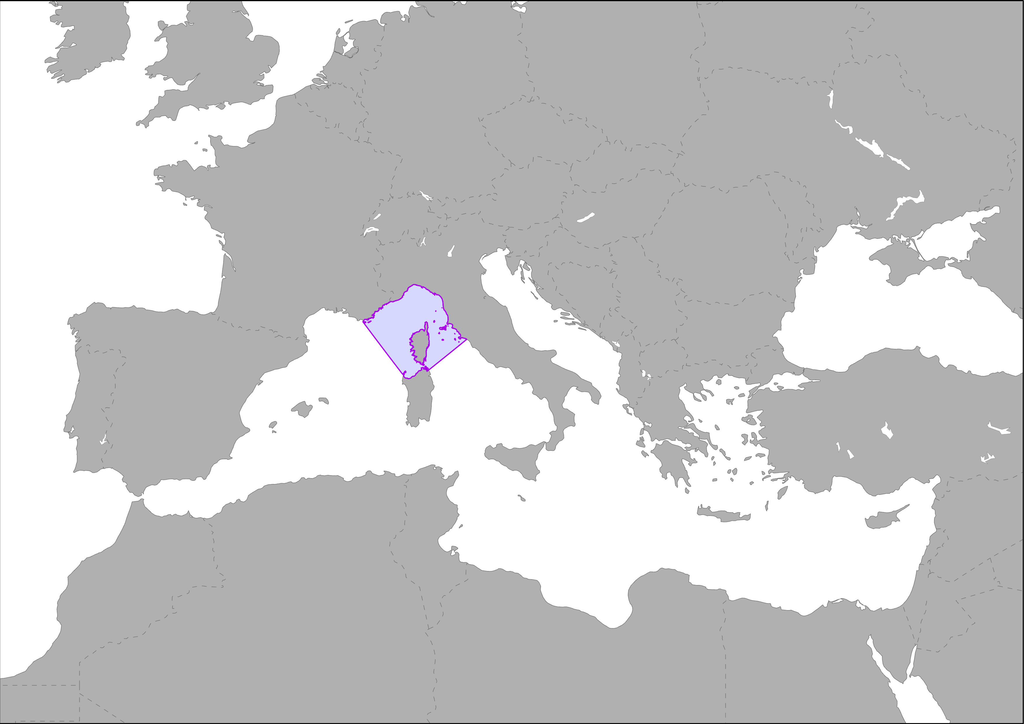
The Pelagos Sanctuary is a marine area of 87,500 sq. km subject to an agreement between Italy, Monaco and France for the protection of marine mammals, which live in it. What makes the Pelagos Sanctuary for Mediterranean Marine Mammals unique is the fact that it is a site managed by three different authorities and includes coastal areas and international waters that form a large ecosystem of major scientific, socio-economic, cultural and educational interest. The entire Sanctuary can be broadly considered to be a biogeographically distinct sub-section of the Large Marine Ecosystem (LME) that is the Mediterranean. This sub-section is marked by greater productivity caused by a variety of mechanisms of fertilization enhancing the level of primary production: coastal waters, the delayed effect of winter mixing, the frontal area, upwelling phenomena and complex structures that combine divergent and convergent features. However, the biodiversity within this sub-section of the Marine Ecosystem of Great Dimension Mediterranean undergoes the combined pressure of natural environmental fluctuations and human impacts. This área is recollected into MAPAMED which is a cartographic database of key information on Mediterranean Marine Protected Areas (MPAs) potential Other Effective área-based Conservation Measure (OECMs), and more broadly on sites of interest for marine conservation. It is developed and administered jointly by UNEP/MAP-SPA/RAC and the MedPAN Association. For detailed information, please consult the MAPAMED user manual (April 2021 version).