
Keyword
Environment
128 record(s)
Type of resources
Available actions
Topics
Keywords
Contact for the resource
Provided by
Years
Formats
Representation types
Update frequencies
Status
Scale
Resolution
panaceaKeywords
GEMET keywords
-
.PNG)
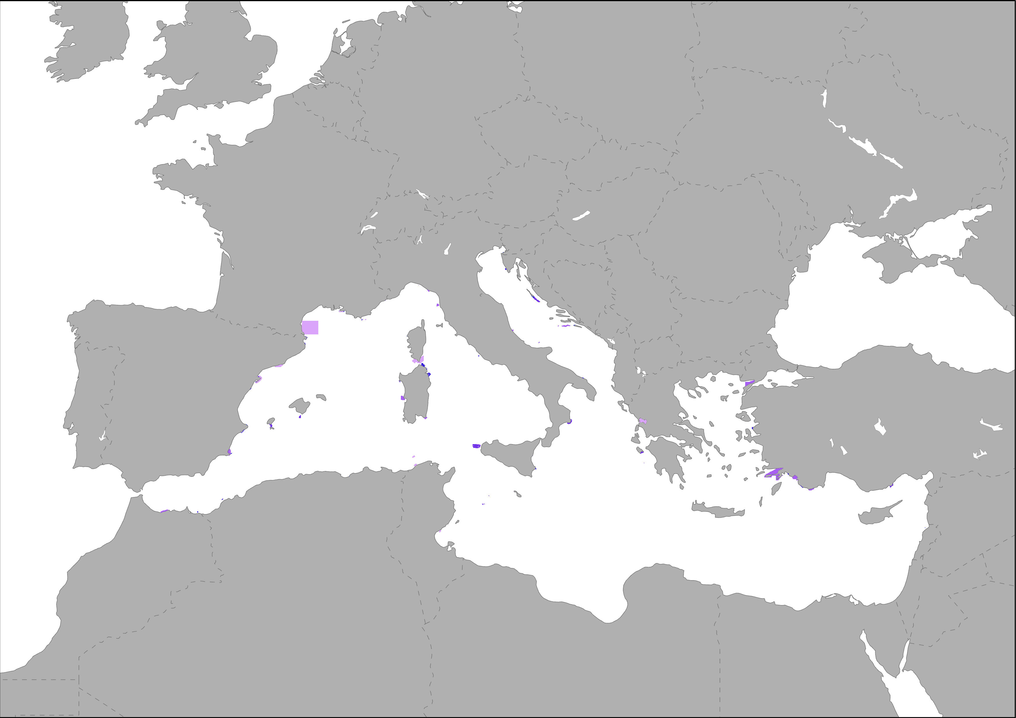
This dataset contains vector data (point) showing the locations of Posidonia oceanica banquettes along the Northern Mediterranean coasts and is composed of different subsets of point occurence data. The dataset was compiled by the Hellenic Centre for Marine Research (HCMR, Institute of Oceanography) in collaboration with the partners of the project "POSBEMED: Sustainable management of the systems Posidonia-beaches in the Mediterranean region". Data collection from Spain, Italy, Greece, Cyprus, and France was based both on tailor-made field and desktop surveys that contacted through a series of questionaires targeting on several target groups. For Spain, Italy, Greece, Cyprus, Croatia, and Malta several locations of Posidonia banquettes digitized on Google Earth. Coverage is the territory of the following EU countries: Spain, France, Italy, Croatia, Greece, Malta, and Cyprus. The dataset collected for the purposes of POSBEMED project should not be considered as exhaustive and its careful use is recommended.
-
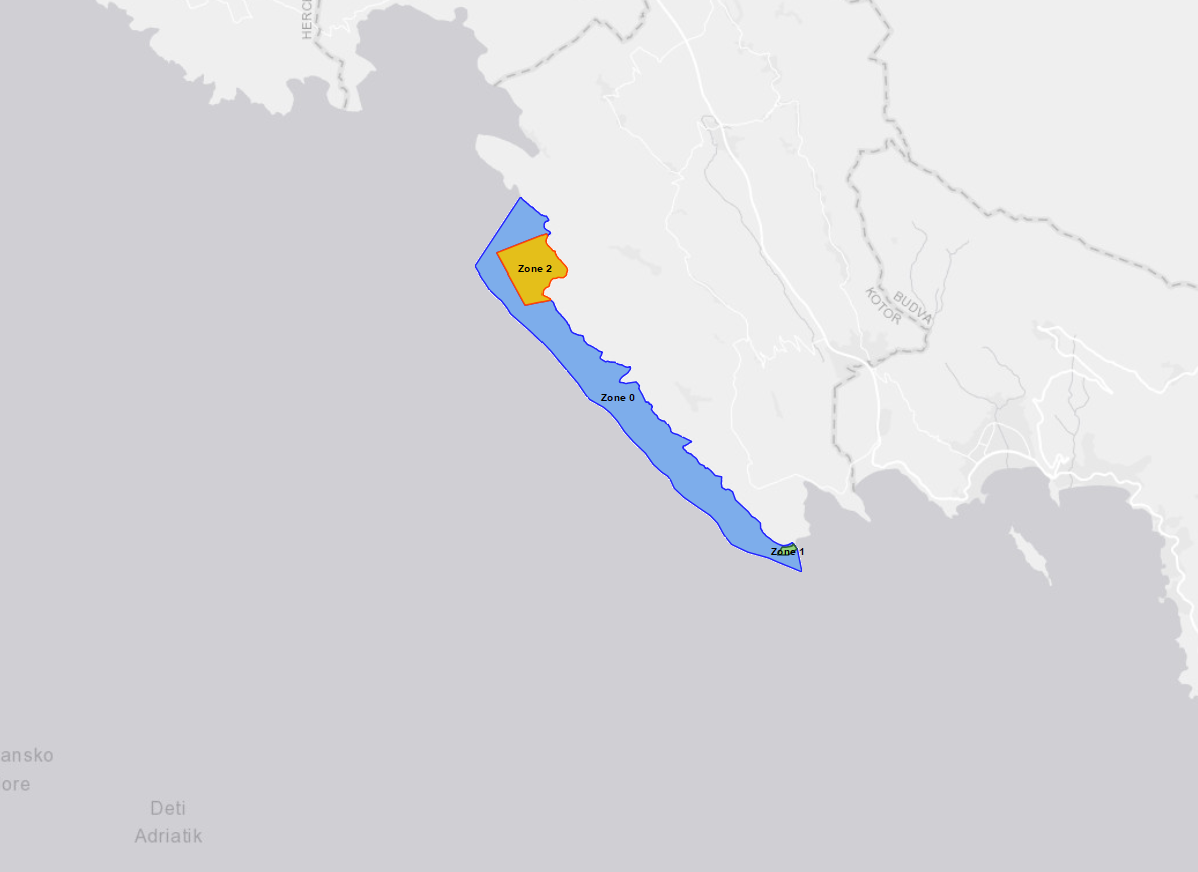
The layer shows the location of Platamuni, first Marine Protected Area in Montenegro which was declared on International Mother Earth Day, 22 April 2021. The Nature Park "Platamuni" is accommodated in the northwest part of the coastal waters in Montenegro, including associated coastline between the Cape Žabica in the northwest and Cape Platamuni in southeast near the beach Ploče. The main reason for proclaiming this first MPA in Montenegro is protecting its ecologically important marine and coastal species and habitats. The Platamuni area is characterized by its main marine cave at the south of Bigova, with at its entrance an extraordinary development of bio-constructions. It also hosts a vast Posidonia oceanica meadow on rock at the western side of Greben Kalafat, continuing by deep coralligenous assemblages on rock. The distribution of caves along the coastline ranges three protected areas: - Zone 0. Platamuni granica zasticenog podrucja - Zone 1. Platamuni II zona zastite morski dio Rt Platamuni - Zone 2. Platamuni II zona zastite morski dio This particular area has benefited in recent years from the support of UNEP/MAP-SPA/RAC, notably through regional projects on marine and coastal protected areas and key habitats mapping in the Mediterranean.
-
.PNG)
This dataset shows where potential interactions of "Posidonia-Banquettes-Dunes" system and coastal/touristic activities exist within 12 selected focus areas along the Northern coasts of Mediterranean Sea. This dataset was compiled by the Hellenic Centre for Marine Research (HCMR, Institute of Oceanography) in collaboration with the partners of the project "POSBEMED: Sustainable management of the systems Posidonia-beaches in the Mediterranean region". The areas with potential conflicts (= red polygons) or without conflicts (= green polygons) locating within the focus area are depicted using the EEA Reference grid of 1x1km.The identification of the areas with potential conflicts was based on an overlay analysis using the following thematic layers: Posidonia beds distribution, presence of Posidonia banquettes, presence of coastal dunes, and presence of coastal/touristic activities produced for the purposes of the POSBEMED project.Coverage is the territory of the following EU countries: Spain, France, Italy, Croatia, Greece, Malta, and Cyprus. The dataset produced for the purposes of POSBEMED project is not exhaustive, and its careful use is recommended.
-
.PNG)
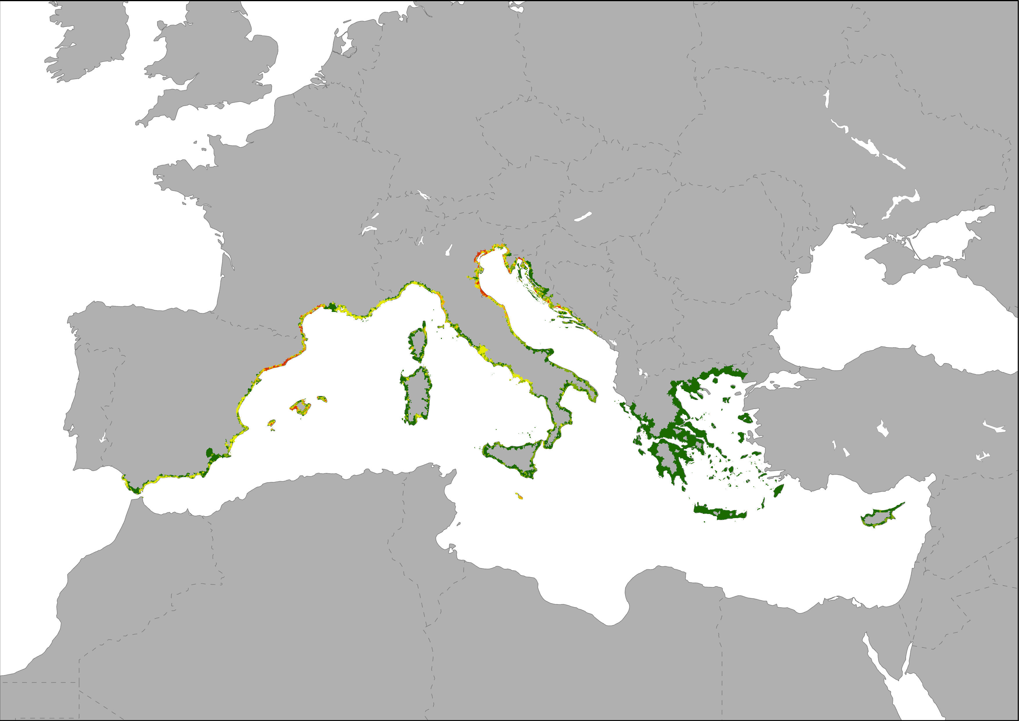
This dataset represents a data compilation of coastal sand dunes distibution along the Northern coasts of Mediterranean Sea. The dataset was compiled by the Hellenic Centre for Marine Research (HCMR, Institute of Oceanography) in collaboration with the partners of the project "POSBEMED: Sustainable management of the systems Posidonia-beaches in the Mediterranean region". Coverage is the territory of the following EU countries: Spain, France, Italy, Croatia, Greece, Malta, and Cyprus. The dataset produced for the purposes of POSBEMED project is not exhaustive, and its careful use is recommended.
-
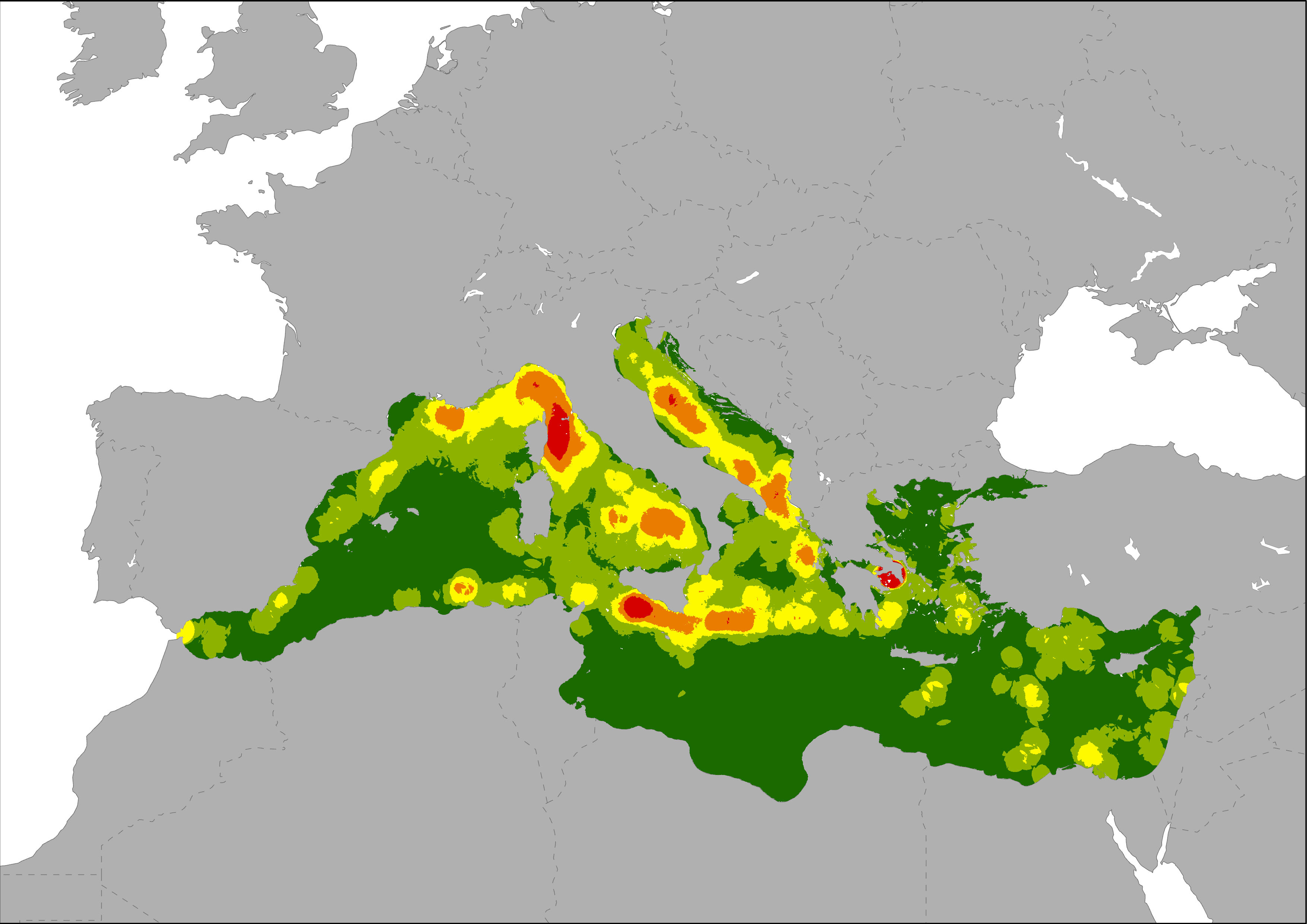
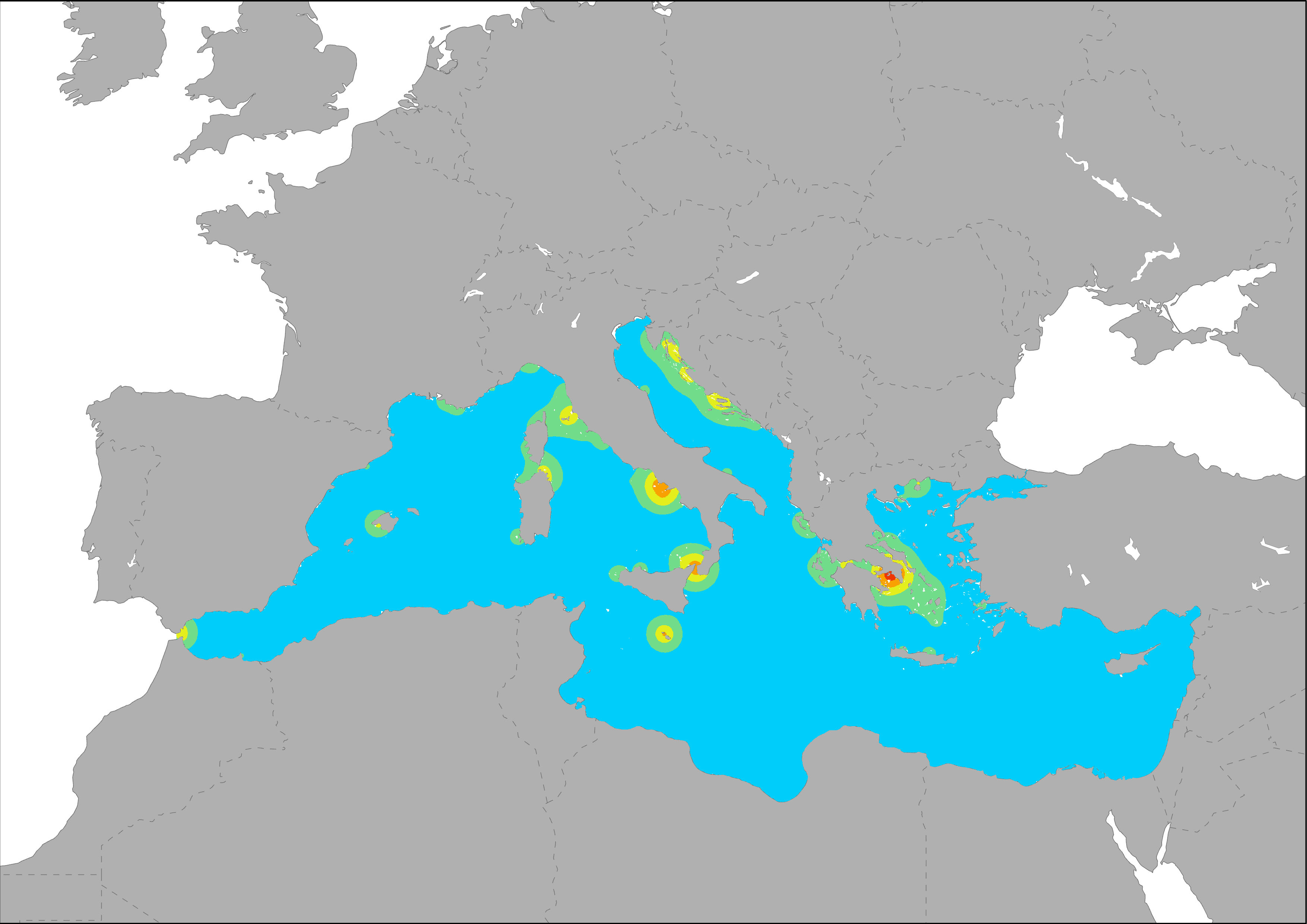
Map showing bed places per km2 as an indicator of the local intensity of tourism capacity. This index is based on Eurostat tourism statistic on bed places and the DMSP-OLS Nighttime Lights Time Series image. Eurostat's tourism capacity statistics differentiate between coastal and non-coastal areas within a NUTS2 region. The total number of beds in coastal areas of a NUTS2 region was disaggregated to the most intense nighttime light emission pixels of the Nighttime Lights Time Series assuming that most bed places are located in areas with high nighttime light emissions. Results are showing low to high intensive tourism capacity per km2 pixel.
-
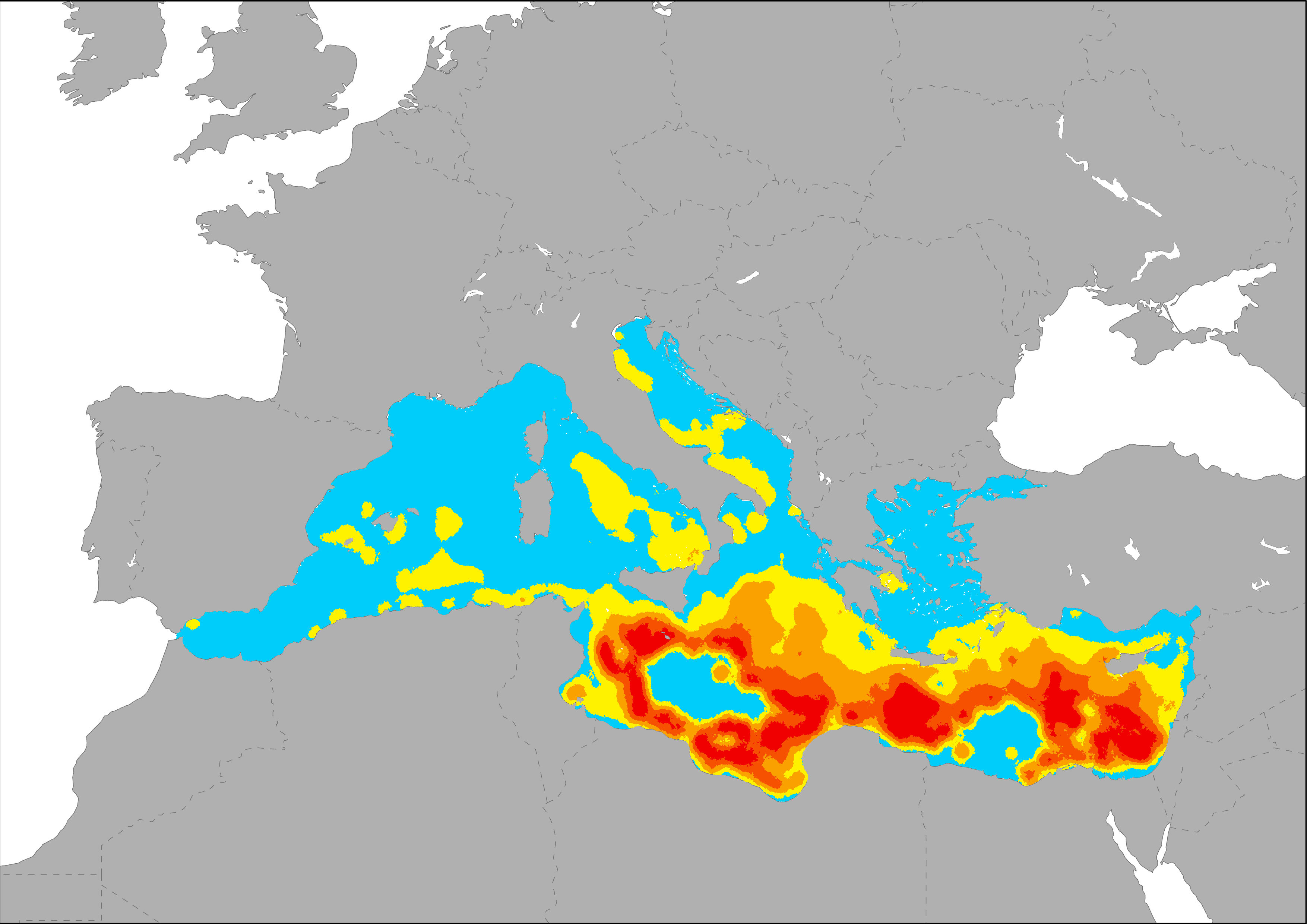
The map shows the spatial distribution of the frequency of oil spills in the Mediterranean Sea, indicating where the probability of an oil discharge is higher. Oil spills were represented as a density layer calculated using data on ship accidents and oil discharges registered by the Mandate of the Regional Marine Pollution Emergency Response Centre for the Mediterranean Sea (REMPEC), and also the oil spills map generated by Cinirella et al., 2012 (based on JRC data, 2009).
-
The indicators represent the distribution and degree of accumulation of marine in the Mediterranean Sea. Main source data were modelled by Lebreton et al., 2012 using a Lagrangian particle tracking model to simulate 30 years of input and transport of floating debris in the world’s ocean. The relative contribution of different sources to the total amount was taken into account in their model.
-
The indicator of management effort was made by summing all the overlapping MPAs on each 1ha pixel across the whole Mediterranean Sea (based on MAPAMED, the database on Mediterranean Marine Protected Areas, MedPAN, RAC/SPA, 2014). One to three points were given to each 1ha-pixel inside MPAs according to the increasing densities of permanent staff and boats for research and surveillance in the MPA; one point was given to all the pixels inside MPAs with management plans (Management effort index). Management effort scores varied from zero to seven.
-
The map shows the distribution of main ferry ports in the Mediterranean Sea. Pressure on marine regions are represented by the port influence area, based also on their activity level. The dispersal of port-derived pollution was modeled as a diffusive plume based on their activity level using Eurostat data on transport of goods (thousand tonnes) and passengers (thousand passengers). Calculations were made following the same methodology developed for ESaTDOR Project (ESPON, 2013).
-

The map shows the distribution of main passengers transport ports in the Mediterranean Sea. Pressure on marine regions are represented by the port influence area, based also on their activity level. The dispersal of port-derived pollution was modeled as a diffusive plume based on their activity level using Eurostat data on transport of goods (thousand tonnes) and passengers (thousand passengers). Calculations were made following the same methodology developed for ESaTDOR Project (ESPON, 2013).